I'm looking for data on the city of Cleon, on Capital, the (I presume) seat of government. I'm trying to flesh out a T5-formatted hex map. The map I've generated here has 1km (inner diameter or center-to-center) small hexes and 10km large hexes. As an aside, the sample map in T5.10 book 3 for the 1 km/10km map is not correct, I'm using true 1km/10km hexes, which is why the hex count is different.
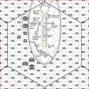
The Moot grounds oval is properly scaled (with a couple of meters or so). I picked an arbitrary point within the geographic mark for Cleon for the location of the Moot itself and based everything on that, it's at {-38.1273, -37.2859} lat/lon and I'm using a spherical world of radius 3826 km, matching the Digest 9 description.
But I don't know a lot about the city of Cleon itself. We know that the Moot Spire is 1750 meters tall, the Palace is 4750 meters away, floating 500 meters over the ground and is a sphere of radius 500 meters. There is a hotel called the Empress Hotel that is 12 km away (which is too far to draw on this map). We know there is a tower that is called the Antiama Library Tower. It's tall, but we don't know how tall. I chose 525 meters which should place it over most of the skyscrapers of Cleon but considerably lower than the Moot Spire. The Library Tower has a view of the nearby Botanical Gardens, and adjacent to the gardens is the University of Sylea and adjacent to that is the Karbiili School. In this map, I devoted just under two hexes to the botanical gardens, three to the university (and the library tower is on university grounds, probably dominating them). I haven't placed Karbiili yet, but I imagine it would be in the hex neighboring both the park and university.
So this is mostly a post asking for what additional canon information is known about the layout of the city and various features of the city of Cleon.

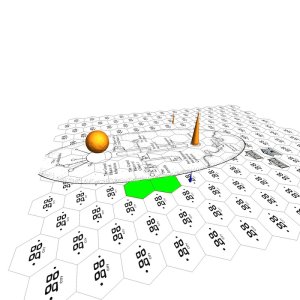
Here's a more 3d orientation. Keep in mind, I just started so everything is very unpopulated, but I wanted to get a sense of the heights of the buildings.

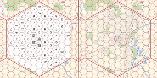
As a side note on mapping: here is my interpretation of the real-world Corvallis, Oregon (I went to school at OSU) using T5 map symbols. I added a symbol for university. At the 1km scale it's not easy to decide what kind of feature dominates a hex: if there's a river and a road both, which symbol should be used?

The Moot grounds oval is properly scaled (with a couple of meters or so). I picked an arbitrary point within the geographic mark for Cleon for the location of the Moot itself and based everything on that, it's at {-38.1273, -37.2859} lat/lon and I'm using a spherical world of radius 3826 km, matching the Digest 9 description.
But I don't know a lot about the city of Cleon itself. We know that the Moot Spire is 1750 meters tall, the Palace is 4750 meters away, floating 500 meters over the ground and is a sphere of radius 500 meters. There is a hotel called the Empress Hotel that is 12 km away (which is too far to draw on this map). We know there is a tower that is called the Antiama Library Tower. It's tall, but we don't know how tall. I chose 525 meters which should place it over most of the skyscrapers of Cleon but considerably lower than the Moot Spire. The Library Tower has a view of the nearby Botanical Gardens, and adjacent to the gardens is the University of Sylea and adjacent to that is the Karbiili School. In this map, I devoted just under two hexes to the botanical gardens, three to the university (and the library tower is on university grounds, probably dominating them). I haven't placed Karbiili yet, but I imagine it would be in the hex neighboring both the park and university.
So this is mostly a post asking for what additional canon information is known about the layout of the city and various features of the city of Cleon.

Here's a more 3d orientation. Keep in mind, I just started so everything is very unpopulated, but I wanted to get a sense of the heights of the buildings.

As a side note on mapping: here is my interpretation of the real-world Corvallis, Oregon (I went to school at OSU) using T5 map symbols. I added a symbol for university. At the 1km scale it's not easy to decide what kind of feature dominates a hex: if there's a river and a road both, which symbol should be used?

