• Welcome to the new COTI server. We've moved the Citizens to a new server. Please let us know in the COTI Website issue forum if you find any problems.

Help with 5.09 World Mapping...

Is there anyone out there who is exquisitely familiar with the World Mapping System in T5.09 who would be willing to take some time and help me learn how to use it? I am really interested in figuring out how to use its randomization to its fullest extent (I love generating random stuff) but I just have a few generalized questions and a ton of specific questions about the process.

The first of the generalized questions is...well... how the hell do I get this started?!? I'm just confused. Here is my system data:

0101 B8A4CCC-F FlHiHtIn {+4} (ABD-2) [BG4J] BEf 613 11 Im G6 VI M6 VI

Then we get into the multitude of specific questions. I picked out the Word Map form for a size 8 planet...then...well, I stare at it blankly. What next? How do I use the terrain hexes? How do I use the local hexes? Do I put 1D mountains in every triangle, or just the non-ocean triangles?

Yes, I know. Map Only As Really Needed. But I enjoy MAMAP (Map As Much As Possible). Consider it a part of my bucket list. :rofl:

Can someone please help me break this down? Thanks in advance.
 
I start by thinking through the stats. B8A4CCC-F is an earth-sized planet with decent air and a lot of water (nearly 100% ocean). That gives me a starting point.

Then I think through the people part: not too many people (10^4, or between 5,000 and 50,000). That probably means they live on or close to the few land masses, since they are probably big enough to support such a small population.

Government C is a charismatic oligarchy, and with law level 13, it's a pretty oppressive world.

With that in my head, I would try to decide how things got the way they are. So, maybe they're a race hardy fishers. With little available land, that can explain the government and law level (with a bit of fleshing out).

Mapping a water world is either trivial (one big map with a few dots of land), or complicated (mapping the bottom of the ocean, perhaps).

With tech level F, these guys have developed techs to take advantage of nearly every facet of basic life. No wonder the oppressive government is still well-liked.

Go from there.
 
I'm really looking to use the random generation system as much as possible. I could certainly just wing it and do things based on feel and theme, but I enjoy the challenge of plotting it out randomly.

Only problem is, I'm having trouble decoding the mapping system in 5.09.
 
Let me start with an example of an aspect that is tripping me up.

On T5.09 page 432, at the bottom of the page beneath the three hex diagrams, it says "Roll 1D to determine (1-2-3=) Black or (4-5-6) White numbers." Obviously the numbers themselves correspond to terrain types, but I can't find any reference that tells me what the color of the numbers represents.
 
Anywhere I note roll 2d6, I use one black die and one red die. Black is the first number, and red the 2nd.

To start, roll 1D. That will select the row for the triangle on the world map. Note that half-triangles wrap to the other end. Then roll another to find the actual triangle, re-roll 5 or 6

If I roll 3, then 5, then the location is triangle 35.

One you know where on the world map you are, roll 1d6. 1-2 is vertex A, 3-4 vertex B, and 5-6 vertex C. Then roll 2d6. This will find the location within that segment of the triangle. I call this a region.

Once you have that spot, roll 1d6.

If the roll is 1-3, you'll be mapping to a hex with black numbers. If 4-6, you'll be mapping to a hex with white numbers.

Then roll 2D -- one will be the first number, and second the first number. For example roll one black die for the first number, and one red die for the second number. This will find your position in the terrain hex.

Example: 1D6 = 4, so this will be a white hex. The roll 2d6, Black die is 3, red die is 5. This will be a hex with WHITE number 3-5 (35)

Then roll 2d6 for the local hex within the terrain hex, and once more for the single hex in the local hex.

Basically you start with the general location on the world, then narrow it down to the local area.

Hmmm...using earth for a generic example. First batch gets you the continent, 2nd batch to the country, 3rd batch to the city, and final to the neighborhood.

Hopefully this helps.
 
If the roll is 1-3, you'll be mapping to a hex with black numbers. If 4-6, you'll be mapping to a hex with white numbers.

Okay, this is where I was getting hung up. This may be the "ah ha" moment. I was thinking that on the world map level you rolled 2D6 (11-66) to assign terrain to that hex. But you're using the roll to pick the hex you're going to zoom into. Okay, that makes much more sense.

Okay, let me take another run at it with that knowledge and see how far I get.

Thank you!
 
One you know where on the world map you are, roll 1d6. 1-2 is vertex A, 3-4 vertex B, and 5-6 vertex C. Then roll 2d6. This will find the location within that segment of the triangle. I call this a region.

Rolling randomly for the world hex, do you count from the vertex until you run out of hexes then return back to the vertex side and continue counting?

So, lets say I roll vertex B (across the bottom) and I start counting to the right. 11, 12, 13, etc. On a size 8 map there are 7 hexes across one face of the triangle. Do I go 11, 12, 13, 14, 15, 16, 21 across the bottom then start back at the left with 22?

The example on T5.09 pg 423 is a bit ambiguous on how to handle sizes other than the triangle pictured.
 
World size doesn't really come into play. This is more a generic method to drill down to a specific area on the planet. The random places page we are working on basically gets you to an area of the planet. A good example for using that page: You've sent the players to find a ship that crashed on a planet. As the referee, you use page 432 to locate the crash site on the planet.

The fine black lines separate the segments on the world triangle. There are three segment - one for each vertex (point) on that triangle.

Vertex A is the upper third, Vertex B is the bottom left third, and Vertex C is the bottom right third of the triangle.

Roll the D6 to figure out which vertex to use, and the 2d6 to figure out the hex in that location.

Position 5-5 is shared by all three. There is no 65 or 66 location. If you roll that result, roll again. Other numbers may also be missing - there are less than 36 hexes per segment.
 
Last edited:
One BIG thing to note - you don't actually map terrain using page 432.

As noted above, I use page 432 for determining a random location or specific place on a planet. I do NOT use it for mapping terrain on the planet.

For terrain mapping, the METHOD is on page 433. The maps you use the METHOD on start on page 440 for the details, and pages 441 thru 456 for the map specific to the world size.

Pages 434-439 deal with populating the hexes on those world maps.

Maps 01 thru 12 are used to map the full world, and correspond to the size of that world.

Maps 13 thru 18 are used to map HALF the world -- you need two of them to map a complete world of size 13+
 
One BIG thing to note - you don't actually map terrain using page 432.
As noted above, I use page 432 for determining a random location or specific place on a planet.
Right, but at this stage that's what I'm trying to do. But when I roll to see which hex I'm "zooming" into I'm not sure how to count out the hexes on the world map scale within the triangle.

I roll the dice. Come up with, say, 34 on the B vertex. How do I count out the hexes from there?
 
I have the same dilemma, GoblinByte. I do disagree with dalthor that p. 432 is not to be used for randomly choosing hexes for terrain in a given triangle: it says "Locations for places (Triangles, World Hexes, Terrain Hexes, Local Hexes) and for the placement of terrain can be randomly selected." It seems to me it can be used both for randomly selecting where that ship crashed, or to place those 1D mountains in a particular world triangle. My apologies, dalthor, if I've misread you.

What the rules say in selecting a hex from a triangle is "If the Triangle is smaller than the roll, re-roll. If the Triangle is larger [a rare occurance, will only be if planet size is 12 or greater] break it into smaller Triangles and then randomly select."

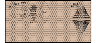
This creates a problem practically. For a Size 8 world, after randomly selecting vertice A, B or C, there's only 12 available hexes from that corner (total of 36 hexes per Size 8 triangle; divide between the three vertices but replicate the centre hex location for all three vertices). That means of the 66 possibilities when you roll, only 12 will be valid, and so almost 5 times out of 6 when you roll that D66, you'll have to re-roll. It's time consuming. And you've got 20 triangles to fill! I'm patient and happy to put some work into a map, but there's a limit.

What I've done as I'm mapping worlds is to do up my own random selection for each size - see attached; sorry, I haven't included Size 8 yet. Generally I leave out one whole edge. If you don't do this, selection is biased towards triangle edges (they get more than one chance to get randomly selected terrain) and the clumps get pretty obvious once you've rolled 1D Mountains for every triangle.

Note that D33 means roll two D3's and use one for tens and the other for units the same as a D66. I use combinations of D3 (=D6 1-2=1, 3-4=2, 5-6=3), D2 (=D6 1-3=1, 4-6=2) and D6 to construct random selections that don't round to a perfect square of 6 (which is most of them). So, D26 will give you 12 evenly-selected possibilities, D36 will give you 18, etc.

Note that mountains that end up being covered by oceans become islands. This gives a pretty neat random distribution of islands.

There are other relatively minor problems with the rules as they stand. 1D mountains applies to all world sizes: this means smaller worlds are much more relatively mountainous than larger ones. Also, as chasms and precipices are placed after mountains, do they replace them or are they added to them? I'm thinking the latter; when you get to World Hex mapping, there's nothing wrong with drawing precipice lines across mountainous terrain as far as I can tell. Also, why so much wasteland all in one clump as World Hexes? And Cropland for Ag worlds is simply enormous, even for low-tech / low-population worlds. So some creative input is required to keep the results making sense in the context of a Word UWP; otherwise a population 6 (millions) agricultural low-tech world can end up with millions of square kilometres per person to cultivate that can't be explained by automation.

One variation I am now definitely using is that when the rules call for placing Oceans by triangle, I randomly select a triangle and place a number of ocean hexes equal to the triangle size in a random or desired shape rather than just draw a line around the triangle and connect it to adjacent oceans. This gives a more natural feel if you decide to draw over your edges with coastlines.

Take a look at the Image Gallery here for some great looking world maps generated by fractal mapping - coliver988 in particular is doing some spectacular work. He's using this fractal mapper and importing the result into GIMP.

Hope this is helpful.
 

Attachments

  • World Triangles for Random Selections.PNG
    World Triangles for Random Selections.PNG
    35.4 KB · Views: 8
Last edited:
A mistake in what I posted: the picture attached mislabels the Size 9 world triangle - it is a Size 8 triangle after all.
 
Back
Top