You are using an out of date browser. It may not display this or other websites correctly.
You should upgrade or use an alternative browser.
You should upgrade or use an alternative browser.
Creating World Maps
- Thread starter Flynn
- Start date
TheEngineer
SOC-14 1K
Thanx for supplying the motivation

Anyway the zoom still look bad and this has to be fixed.
Besides, the above view is a result of FT2s Gaia shader, so its not an altitude or climate map, but something in between. Sadly there is no way to tweak some of its parameters, so the general style usually is the same ....
The pretty cool thing having it in FT is, that now you can choose different layout views and export into different projections (like icos), too.
Regards,
TE
Hi Hyphen.What I did - and it took some time - was to sit down with Grand Survey and try to map out Tavonni, by hand, using the plates, continents, islands, etc that I had rolled up randomly using their tables. Um, sorry that it doesn't match reality.
")

I did at least *try* to make the plate movements seem to go in the same direction, rather than having the same plate move north at one point and south at another point *on the same boundary*. After I placed the plates, I tried to think about what similar plates were doing on ol' Terra, and place my landmasses accordingly. However, I'm not a geologist, nor do I play one on tri-dee.
I'm trying to workout when the Tavonni Map was first drawn up. I remember first see it at Groveland. Is it Groveland or Pre Groveland?
Gnoll110
Dear Folks -
I first wrote up Tavonni back in 1986 or so (which explains why the map is so yellowed).
Definitely pre-Canberra days.
Hi Gnoll, how's sunny Queensland?Originally posted by Gnoll110:
I'm trying to workout when the Tavonni Map was first drawn up. I remember first see it at Groveland. Is it Groveland or Pre Groveland?
I first wrote up Tavonni back in 1986 or so (which explains why the map is so yellowed).
Definitely pre-Canberra days.
I wouldn't mind having some one with geological knowledge take a quick pass at my Fantasy world of Karnorthe which was done with FT2. It would be interesting to see what the tectonics of the world would be. I won't post it here but some of you may have seen the global view of the world which was done with FT23 and Bryce 5.
If anyone is interested it is at
http://karnorthe.skaran.net
My actual Traveller site (which is in need of some updating) is at
www.skaran.net
If anyone is interested it is at
http://karnorthe.skaran.net
My actual Traveller site (which is in need of some updating) is at
www.skaran.net
GypsyComet
SOC-14 1K
I can see a couple possible scenarios for it, but to fit your own work I'd need to know where the active volcanos are. You almost don't have *enough* land for the tectonics to be really obvious. The webbing of shallow seabed lines to the west is going to be interesting to explain unless magic is involved or you've lost a whole continent recently...Originally posted by Antony:
I wouldn't mind having some one with geological knowledge take a quick pass at my Fantasy world of Karnorthe which was done with FT2. It would be interesting to see what the tectonics of the world would be. I won't post it here but some of you may have seen the global view of the world which was done with FT23 and Bryce 5.
If anyone is interested it is at
http://karnorthe.skaran.net
TheEngineer
SOC-14 1K
Hi !
Regards,
TE
Maybe a major asteroid impact once upon a time ?Originally posted by GypsyComet:
...
The webbing of shallow seabed lines to the west is going to be interesting to explain unless magic is involved or you've lost a whole continent recently... [/QB]
Regards,
TE
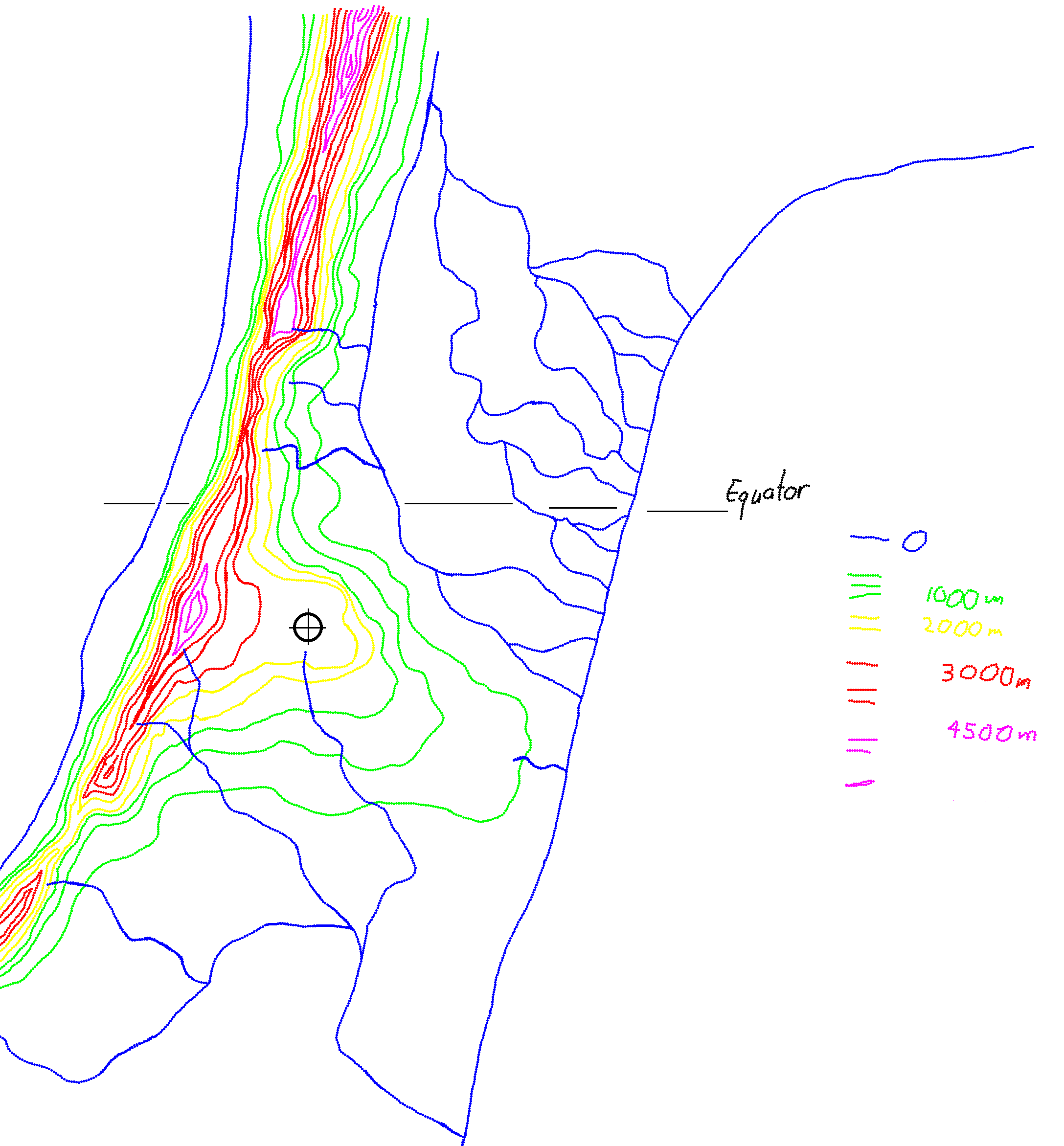
Sadly the original handdrawn map which had the tectonic plates marked vanished millenia ago. My notes indicated that there were 8 principal plates.
The world is geologically quite active largely due to the presence of three moons, one large and two small.
There are supposedly 23 notable volcanoes. most of these I would place along the mountain range running East-West on the continent of Ethryn, a second group runs in an arc along the "spines" of Golanza and Thalryn. Then there is the huge volcano on the north east portion of Velexar. Propbably would not be pleasant if it erupted! This structure peaks at about 32,000 feet with a central crater about 50 miles across.
It does appear that at some time in the past there was a phase of asteroid bombardment which will have complicated things, certainly some of the seabed formations looks vaguely like eroded impact craters.
FT is not really condusive to plate tectonics. Though it would be interesting to see how this arrangment can be explained.
Bringing it back to Traveller I do use the same system (with high local psionics) as the main world in the Eta Cassiopeia system. The world itself would of course be Red Zoned in the Imperium, probably also in the Solomani Confederation as well.
Dear Folks -
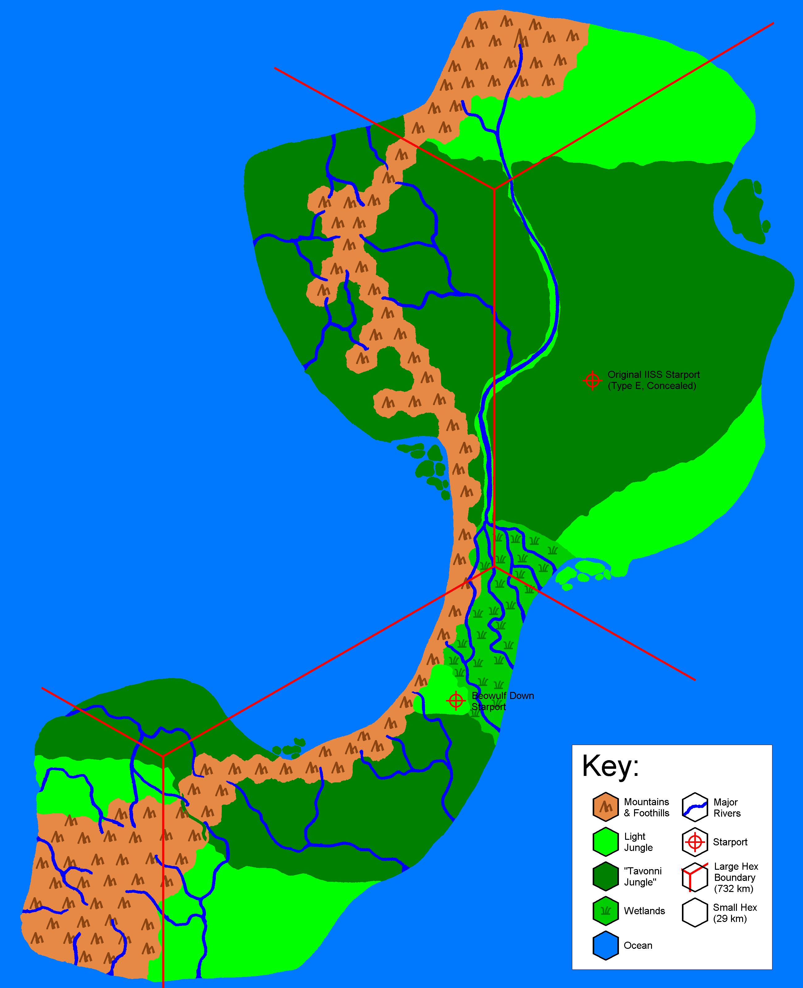
As promised, I've *finally* got my finger out and traced, scanned, and coloured the detail map of Björnöya Island (click image for full-size pic):

If you look back at the Tavonni world map, it's the island on the right where the starport is:
Next project is the close-in map of The Plateau, then the 'port itself.
The Plateau is the light green area that Beowulf Down is perched upon. I kinda envisioned something like the Altiplano, overlooking the Amazon Basin (albiet on a smaller scale). The Plateau is about 2000 m above sea level.
As promised, I've *finally* got my finger out and traced, scanned, and coloured the detail map of Björnöya Island (click image for full-size pic):
If you look back at the Tavonni world map, it's the island on the right where the starport is:
Next project is the close-in map of The Plateau, then the 'port itself.
The Plateau is the light green area that Beowulf Down is perched upon. I kinda envisioned something like the Altiplano, overlooking the Amazon Basin (albiet on a smaller scale). The Plateau is about 2000 m above sea level.
[snip]Originally posted by Hyphen:
Dear Folks -
As promised, I've *finally* got my finger out and traced, scanned, and coloured the detail map of Björnöya Island...
...And apologies to those who've already grabbed the map - a *slight* review of scale has taken place (can someone check my maths?).
Ahem.
Tavonni is size 5, and many years ago I rolled 5066 miles for its diameter. This equates to some 8153 km, which gives a circumference of 25,613 km.
According to the blank map sheets, you then divide by 35 to get the size of a hex, which is 732 km, not the 232 I previously came up with. The small hexes, therefore, are 29 km across, not 9 km.
I have adjusted the large versions of the maps accordingly (and, since you can't even read the text in the smaller versions, been slack and not amended them.
)Just thought this thing needed to be bumped.
By the way, TE, could you explain the procedure you used to flatten the Tavonni map? Preferably, with any necessary UV-mapped spheres in .obj format?
I've spent the last three months off and on prowling the internet and drooling over great heightmap manipulation software: l3dt, leveller, wilbur, world machine. I love my mac, but in this one area I envy the PC people. I've been trying to write a half-assed leveller ripoff in java, but it's hard to write a semi-sophisticated program and learn graphics and gui programming at the same time. Suffice to say, I haven't gotten very far.
Hey, if there are any java graphics programmers out there interested in such a thing, perhaps this could be a collaborative effort?
TheEngineer
SOC-14 1K
Hi !
Alik, Tavonni map flattening was quite a pain
I "simply" used a painting program to distort the upper and lower triangles back into rectangles.
This way was choosen, because I was unable to convince my 3D software to do the re-mapping as I wanted it to do.
What excactly do You want to do ?
(Engineers always need a specification).
regards,
TE
Oh well, I was hoping for a general, "plug-and-chug," solution. I was kind of afraid it would be a case-by-case thing, but hoping.
I was intending to apply said general solution to the Regina map on page 91 of DGP's World Builder's Handbook. Purely for personal enjoyment; I don't want to get the local copyright lawyers uptight. I prefer Mollweide for area determination and plate carée to find latitude and longitude. I have formulae to calculate great circle and constant-bearing distances given that.
Would you be willing and able to explain the method you used in greater detail, or was your work too extemporaneous?
The programming project is on indefinite hiatus. I think it damaged my brain trying.
Imagine the vertical bars are square brackets:
|URL=http://someplace.com/bigimage.gif| |IMG]http://someplace.com/littleimage.jpg|/IMG| |/URL|
Basically, just nest your image inside a link.
I just upgraded to Bryce 6.1. I think I will try the Tavonni map with that, then give up.
|URL=http://someplace.com/bigimage.gif| |IMG]http://someplace.com/littleimage.jpg|/IMG| |/URL|
Basically, just nest your image inside a link.
I just upgraded to Bryce 6.1. I think I will try the Tavonni map with that, then give up.
TheEngineer
SOC-14 1K
Hi Alik !
Sorry I had to refresh my own memory, how I did that transformation.
Well, in fact I used my 3D software to re-distort the triangles into rectangular shapes, because I found no freely available graphics software to do that.
E.g. Gimp provides a way to distort a selection, but only on the basis of a rectangular selection, while you would need a triangular one.
Guess we hit a very rarely needed use-case here
Next I will try to take a look at morhing software, which could perhaps be used for that...
regards,
TE
Thanks Alik, it's good to have thumbnails so people don't have to wait forever for their connections to load. If you are going to try the Tavonni map using Bryce, have a look a the 3d mapping tutorial I posted in the Software solutions section - it may (or may not) be helpful.
Just testing:

Just testing:

TheEngineer
SOC-14 1K
Hi !
Ok, I created a map surface and an UV-mapped texture map, which stores the original ico-map.
The result is a slightly inperfect equirectangular map
Now, I wonder if this might be useful in another 3D package, if exported to obj or whatever....
regards,
TE
Ok, I created a map surface and an UV-mapped texture map, which stores the original ico-map.
The result is a slightly inperfect equirectangular map
Now, I wonder if this might be useful in another 3D package, if exported to obj or whatever....
regards,
TE
Similar threads
- Replies
- 78
- Views
- 2K
- Replies
- 73
- Views
- 8K
- Replies
- 4
- Views
- 609
- Replies
- 6
- Views
- 3K